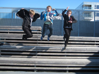


It has been raining now for ages it seems. But in early May we had wonderful days when the arctic spring was trying to get a hold on Strandkanten. We have been living here in our own project for a year now- as an experiment- in a random choice of one of the apartments we have designed. It has been a positive experience. We’re also happy about the landscape project, which are under completion these days, made by Aurora Landscape in collaboration with Ljusarlitektur, 70°N and D&U. Landscape architect Anita Veiseth has done a great job in facilitating the project for teenagers. The young boys, 13-19 years old have already made this landscape their spot in Tromsø. They are hanging out, playing football-games, basket ball and of course skating. Through the Game of Tromsø, we discovered the urban potential of the area. In 2000, as a part of a political process, we reworked the master plan for Strandkanten in collaboration with 70°N and Code.
Thursday, June 11, 2009
WONDERFUL DAYS
Labels: architecture, in english, project, Tromsø
Sunday, June 7, 2009
The Northern Norway Architecture Award

Knut Eirik Dahl has recieved the Northern Norwegian Architects Association's Honour Award for his enduring efforts to increase the understanding for -and raise the quality of- our urban environments. .
The two architectural awards for 2009 were given to:
- Ungdomshuset Straumanstua in Lofoten by Jarmund/Vigsnæs
- The rehabilitation of Hamningberg in East Finnmark.The project has been a collaboration between Båtsfjord, Vardø, Finnmark Fylkeskommune, Riksantikvaren and Statens Vegvesen.
The prize ceremony for the Northern Norway Architecture Award was in Tromsø at NAF's annual meeting, june 5.
Friday, June 5, 2009
World Environmental Day 2009
Today it is World Environmental Day! On the WED homepage you can get the daily do something TIP, join the Climate Heroes and more...
Labels: climate change, in english
Melting Ice // The Map Collection

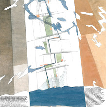
This map from 2006, which we made for the arctic cities exhibition at the 10'th architectural Biennale in Venice together with a great team, shows the early estimates for the meltdown of the ice cap. Today we know for a fact that the process is going much faster. Two years later Jan Gunnar Winther, Director of the Norwegian Polar Institute in Tromsø, stated: ”The summer of 2007 was a record year climate-wise: the ice in the Arctic was down 20% from the previous record year in 2005. The September Ice in 2007 was historically small in scale and one thus expects a new record low in 2008. Mathematical climatic models has not been able to take into account these fast changes. They don’t reproduce reality well enough.” The climate change sets new conditions for spatial planning. Read more in Appearing and disappearing Landscapes in On Site, the book will be launched at the Architekturforum in Zurich tomorrow.
related link: Earth Observatory // World Of Change
Labels: climate change, in english, The Map Collection
Tuesday, June 2, 2009
Many Strong Voices // COP 15
Yesterday we got two interesting links at Cicero's news update service on climate change: “Climate change in the Arctic is a human issue, a family issue, a community issue, and an issue of cultural survival. The joining of circumpolar peoples with Pacific Island and Caribbean States is surely part of the answer in addressing these issues. Many small voices can make a loud noise. As we melt, the small developing island states sink.”
Sheila Watt-Cloutier, 2007 Nobel Peace Prize Nominee
Many Strong Voices
FNs klimapanels siste hovedrapport omtaler Arktis og lavtliggende øyer i Karibien, Stillehavet og andre steder som noen av de mest sårbare områdene for klimaendringer. Alliansen Many Strong Voices skal jobbe for en internasjonal klimaavtale med omfattende globale utslippsreduksjoner.
Utsatte grupper hever stemmen
Labels: climate change, in english
Monday, June 1, 2009
Manhattan Transfer // The Map Collection

Along the ridge of Tromsø Island there runs a band of continues woodlands – the Tromsø Common – which in size and extension corresponds to that of Central Park in New York. Back in 1994 we superpositioned Manhattan on this map over the Tromsø Island. Tromsø was experiencing an explosive urban growth, and it was necessary discuss the lokal attitude towards nature as an unlimited resource. The Tromsø common vas already changing from being nature to become a park. 14 years later the map still has actuality in the urban discource i Tromsø - it has proved to be a valid statement.
The fact that we have an urban park of an international format is the most visible urbane trait in Tromsø that necessitates a further urbanisation. The Green Line bind all the city areas together, in winter functioning almost as a metro for cross-country skiers and families on a hike.
Skating in Central Park
The United States of Barents // link // The Map Collection

Web-fiction, based on the performance at PAN-BARENZ
Artist/musician Amund Sjølie Sveen speaks to us back from 2036 and tries to analyze the changes that have lead to establishment of the USB and proves that the opening of a new IKEA-store in HaparandaTornio in 2006 is a major event in the history of the Barents Region. What happens when the region experiences a potential change from periphery to center? Why are we all talking English to each other? Welcome to the brave new world of the United States of Barents!
Labels: in english, The Map Collection
Friday, May 29, 2009
D&U ONLINE PAPERS // GUEST // Peder Agger and Jesper Brandt // The Dynamics of Small Biothopes in Danish agricultural landscapes


The Danish biologist Peder Agger and the geographer Jesper Brandt, published in 1986 the result of 10 years of research, analysis and wanderings through the text The Dynamics of Small Biothopes in Danish agricultural landscapes. It describes a landscape under pressure, it raises the question about the vulnerability of the landscape, about relationships, and describes this as voices that speak to us about survival. It is a classic text in landscape research and made a strong impression on us when we found it on the web two years ago. Peder Agger is Chairman of the Danish Council of Ethics and professor at the Department of Environment, Technology and Social Studies, Roskilde University, Denmark. Jesper Brandt is Professor at the Department for Geography and International Development Studies, RUC and at ENSPAC (Department of Environmental, Social and Spatial Change). link to: The Dynamics of Small Biothopes in Danish agricultural landscapes
Labels: in english, ONLINE PAPERS
Thursday, May 28, 2009
Mapping the Seabed // MAREANO // link // The Map Collection

This screenshot of the MAREANO map viewer shows the area of hydrographic survey data at the Norwegian continental shelf, an area bigger than the Norwegian mainland. On the MAREANO map wiever you click into registrations, images and videos of the seabed.
Global heating increases the pressure on coastal areas and ocean zones, the seabed itself and the quality of the ocean areas are at stake – the resources here constitute the world’s future "granaries" and "larders". It is the mapping and change of this seascape that now appears as the big challenge – a future and appearing landscape undergoing a dramatic and complex process of change. This environmental mapping’s collision with the mapping of fossil resources can from hegemonic milieus be seen as a disturbing mapping.
MAREANO maps depth and topography, sediment composition, biodiversity, habitats and biotopes as well as pollution in the seabed in Norwegian coastal and offshore regions.The MAREANO Programme aims to provide answers to questions such as: How is the seascape of the Norwegian continental shelf? What does the seabed consist of? How is the biodiversity distributed on the seabed? How are habitats and biotopes distributed on the seabed? What is the relationship between the physical environment, biodiversity and biological resources? How are contaminants stored in sediments? MAREANO is coordinated by the Institute of Marine Research, in collaboration with the Geological Survey of Norway and the Norwegian Hydrographic Service.The Programme is financed by the Ministry of Fisheries and Coastal Affairs, the Ministry of Environment and the Ministry of Trade and Industry via contributions from the National Budget.
Se også Forvaltningsplan Barentshavet og havområdene utenfor Lofoten og Helhetlig forvaltning av det marine miljø i Norskehavet
Norwegian Journal of Geology – online:
Sediment characteristics and environmental implications
in the Lofoten - Barents Sea region
"In this issue of NJG we present papers focusing on (sub-) recent geological and biological characteristic of the Lofoten - Barents Sea region. This theme covers a wide range of studies ranging from large-scale submarine landscape evolution to small-scale biological diversity. A common aspect of most papers is the attempt to describe the interaction of geological and biological processes in the Lofoten - Barents Sea region and the implications these have for environmental changes. Most of the research has been performed under the umbrella of the MAREANO (Marine AREal Database for NOrwegian Waters) program, its first phase from 2005 to 2010 being funded by the Norwegian Government." Read the articles here: NJG 2009 Volume 89 Nr. 1 & 2
...men forskere får ikke miljøkartlagt havbunnen utenfor Lofoten før regjeringen skal vurdere oljeboring.... "I 2004 opprettet myndighetene havforskningsprosjektet Mareano. Mareano skulle kartlegge biologisk mangfold på havbunnen i nordområdene. Men på grunn av lave bevilgninger over mange år, blir ikke prosjektet ferdig. Blant annet vil ikke Nordland 6 bli kartlagt i det hele tatt." Les mer i Hundre millioner mangler (Dagbladet 17.8.2009)
Nyhet 10.09.09: Arbeidet med de 17 første områdene i Nasjonal marin verneplan er i gang. Planen er den første i sitt slag for å verne undersjøisk natur.Les mer her:Skal verne natur under vann
Sweeden has enviromental informaton on their coastal areas at this page: Havsmiljøn and on the viewer Vattenkartan
See also: The EU Water Framework Directive and Breathless coastal seas, and for the Baltic Sea:
WWF: Baltic Ecoregion Programme
Documentary on cod fishing in the Baltic Sea
Labels: in english, The Map Collection
Kartlegging av havbunnen

Lørdag hadde Nordlys en fire siders reportasje om funnene som havforskerne har gjort under kartleggingen av havbunnen utenfor Lofoten/ Vesterålen og Troms. Det er oppsiktsvekkende og ny kunnskap som her refereres. Og den vil gripe rett inn i den debatten om petroleumsaktivitet som kommer f or fullt når forvaltningsplanen skal revideres.
Les videre i Oddvar Nygårds kommentar over!
Bildet er tatt på et av Mareano prosjektets forskningstokt og viser et korallrev på 214m dyp på terskelen til Stjernsund ved Altafjorden.
MAREANO kartlegger dybde, bunnforhold, biologisk mangfold, naturtyper og forurensning i sedimentene i norske kyst- og havområder.
Labels: in norwegian, media, Tromsø


