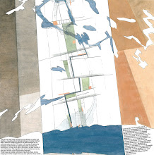
This map was our starting point for an investigation on a city development in Stavanger in 2000. It led, together with Paolo Viganos lecture in Cordoba (Europan, 2003) to the text ”Topografiske attraksjoner” (topographical attractions), published in Arkitektnytt in 2003.
In the spring 2010 we will revisit the study field of Jæren through the course, Appearing and Disappearing Landscapes, which is part 2 of AHO's "Research on the Norwegian Landscape". The course is an inter-Nordic cooperation between the AHO and Forests and Landscape at Copenhagen University. Jæren is a region that today has the largest urban growth in Norway after Oslo. The region, which is the centre of oil development in Norway, is now entering into a new phase, causing both landscape and urbanity to be in need of reinterpretation. The course will establish recognition on the larger scale that will affect knowledge built up during the course work. The UN climate conference, COP 15, in December 2009 will send out signals concerning this larger scale.
The Course is planned as a discourse between landscapes and urban conditions that range from the smallest biotope to the larger future image. Students will throughout the semester work on individual projects as experiments in the relationship between different territorial contexts and urban strategies; this will entail both a smart and innovative cartography and conceptual design projects.
Monday, June 15, 2009
Why Here? // The Map Collection

Sunday, June 14, 2009
BYEN UNDER PRESS

Uroen som ligger som en undertekst i alle artiklene i siste nummer av Marg framkaller denne headingen; byen under press. Peter S. Jørgensen sin tekst New York – retten til byen beskriver hvordan nye bevegelser og understrømmer i megabyen er i kontinuerlig dialog og konflikt med administrative virkeligheter og planleggingsteser. I Weekendavisen nr 24, 12. juni har han besøkt utstillingen Fremtidens arkitektur er grønn. Arkitekturens grenser II på Louisiana.
I artikkelen Framtiden er uvissen utvikler han sine New York oppdagelser slik, etter å ha sett MITs klimaadvarsler på utstillingen:
”Det er ikke nok at tro, at vi kan genopprette en balance. Det bliver nødvendig med en løpende og dynamisk tilpasning til de dramatiske klimaændringer. Hvordan udvikler vi vores civilisation under disse skiftende vilkår?
Byen kan kun blive løsningen via borgernes deltagelse. På den måde kan der ske en professionalisering og demokratisering, hvor borgerne i de sociale nættverk, virksomheder og bymiljøer spiller sammen som urbane fællesskaber. Det er i disse urbane fællesskaber
- der kan transformere seg sammen med byen – at tilpassningen til klimaændringerne kan foregå dynamisk og hurtig nok”.
Universitet i Agder er midt inne i sitt forskningsprosjekt City and Tolerance.
15. og 16. juni arrangere UIA et fagseminar med overskriften Byplanens dilemmaer.
Knut Eirik foreleser på dette seminaret under seminaroverskriften hva kan byplanleggingen tilby og med forelesningstemaet Byen under press som drar noen linjer videre fra det Peter S. Jørgensen åpner for. Heri inkludert noen nye betraktninger rundt Byutviklingens År 05.
Her møter han bla Roy T. Eriksen som foreleser om Vandringer i et ruinlandskap som er en utvikling av hans tekst i siste nummer av tidsskriftet Marg.
Til Kristiansand kommer også Jonny Aspen som stiller spørsmålet trenger vi byteorien og John Pløger som utdyper hva som gjør byrom til samhandlingsrom.
Toleranse, litteraturen og byen er temaet for en kveldsforestilling i Håndverkeren den 15. der John Pløger, Paal-Helge Haugen, Torild Wardenær og Knut Eirik Dahl skal skape noen åpninger.
Friday, June 12, 2009
Resistance // The Map Collection

Each element, every trace describing the appearing manufactured and spiritual landscape is to be considered as resisting change, interposing processes which resists and reformulate actual interventions in space.
A canal or a lake can thus fashion a word of ideas for what is to follow. A planted forest will after 20 years demand respect and care. An area in which all of nature is subject to change during 30 years will by virtue of that change draw attention to itself and become an alternative to all development strategies. Our concept entails exploring how such an incipient landscape shapes its capacity for resistance, in other words how it is shaped in time.
We made this map over Ørestaden in 1994 as a part of The Magic Carpet.
Thursday, June 11, 2009
WONDERFUL DAYS


It has been raining now for ages it seems. But in early May we had wonderful days when the arctic spring was trying to get a hold on Strandkanten. We have been living here in our own project for a year now- as an experiment- in a random choice of one of the apartments we have designed. It has been a positive experience. We’re also happy about the landscape project, which are under completion these days, made by Aurora Landscape in collaboration with Ljusarlitektur, 70°N and D&U. Landscape architect Anita Veiseth has done a great job in facilitating the project for teenagers. The young boys, 13-19 years old have already made this landscape their spot in Tromsø. They are hanging out, playing football-games, basket ball and of course skating. Through the Game of Tromsø, we discovered the urban potential of the area. In 2000, as a part of a political process, we reworked the master plan for Strandkanten in collaboration with 70°N and Code.
Sunday, June 7, 2009
The Northern Norway Architecture Award

Knut Eirik Dahl has recieved the Northern Norwegian Architects Association's Honour Award for his enduring efforts to increase the understanding for -and raise the quality of- our urban environments. .
The two architectural awards for 2009 were given to:
- Ungdomshuset Straumanstua in Lofoten by Jarmund/Vigsnæs
- The rehabilitation of Hamningberg in East Finnmark.The project has been a collaboration between Båtsfjord, Vardø, Finnmark Fylkeskommune, Riksantikvaren and Statens Vegvesen.
The prize ceremony for the Northern Norway Architecture Award was in Tromsø at NAF's annual meeting, june 5.
Friday, June 5, 2009
World Environmental Day 2009
Today it is World Environmental Day! On the WED homepage you can get the daily do something TIP, join the Climate Heroes and more...
Melting Ice // The Map Collection

This map from 2006, which we made for the arctic cities exhibition at the 10'th architectural Biennale in Venice together with a great team, shows the early estimates for the meltdown of the ice cap. Today we know for a fact that the process is going much faster. Two years later Jan Gunnar Winther, Director of the Norwegian Polar Institute in Tromsø, stated: ”The summer of 2007 was a record year climate-wise: the ice in the Arctic was down 20% from the previous record year in 2005. The September Ice in 2007 was historically small in scale and one thus expects a new record low in 2008. Mathematical climatic models has not been able to take into account these fast changes. They don’t reproduce reality well enough.” The climate change sets new conditions for spatial planning. Read more in Appearing and disappearing Landscapes in On Site, the book will be launched at the Architekturforum in Zurich tomorrow.
related link: Earth Observatory // World Of Change
Tuesday, June 2, 2009
Many Strong Voices // COP 15
Yesterday we got two interesting links at Cicero's news update service on climate change: “Climate change in the Arctic is a human issue, a family issue, a community issue, and an issue of cultural survival. The joining of circumpolar peoples with Pacific Island and Caribbean States is surely part of the answer in addressing these issues. Many small voices can make a loud noise. As we melt, the small developing island states sink.”
Sheila Watt-Cloutier, 2007 Nobel Peace Prize Nominee
Many Strong Voices
FNs klimapanels siste hovedrapport omtaler Arktis og lavtliggende øyer i Karibien, Stillehavet og andre steder som noen av de mest sårbare områdene for klimaendringer. Alliansen Many Strong Voices skal jobbe for en internasjonal klimaavtale med omfattende globale utslippsreduksjoner.
Utsatte grupper hever stemmen
Monday, June 1, 2009
Manhattan Transfer // The Map Collection

Along the ridge of Tromsø Island there runs a band of continues woodlands – the Tromsø Common – which in size and extension corresponds to that of Central Park in New York. Back in 1994 we superpositioned Manhattan on this map over the Tromsø Island. Tromsø was experiencing an explosive urban growth, and it was necessary discuss the lokal attitude towards nature as an unlimited resource. The Tromsø common vas already changing from being nature to become a park. 14 years later the map still has actuality in the urban discource i Tromsø - it has proved to be a valid statement.
The fact that we have an urban park of an international format is the most visible urbane trait in Tromsø that necessitates a further urbanisation. The Green Line bind all the city areas together, in winter functioning almost as a metro for cross-country skiers and families on a hike.
Skating in Central Park
The United States of Barents // link // The Map Collection

Web-fiction, based on the performance at PAN-BARENZ
Artist/musician Amund Sjølie Sveen speaks to us back from 2036 and tries to analyze the changes that have lead to establishment of the USB and proves that the opening of a new IKEA-store in HaparandaTornio in 2006 is a major event in the history of the Barents Region. What happens when the region experiences a potential change from periphery to center? Why are we all talking English to each other? Welcome to the brave new world of the United States of Barents!