The competition of Ørestaden in 1994 can be seen as Copenhagen’s urban answer to the Öresund Bridge project. The program for Ørestaden was as ambitious as for Nordhavnen, but in a different time. Here the ambitions of Copenhagen as an important city in a European economic picture were dominant (new Docklands etc.) The ideal world of Ørestaden, as a line of growth out towards Amager’s periphery, have not however been sustained in dialogue with the larger image of the city. More interesting urban developments have taken place in other parts of Copenhagen, and ideas and ambitions have disintegrated in Ørestaden’s era.
Nordhavnen has now been designated as the place for seven present ambition’s criteria summed up as ‘The Sustainable City of the Future’. As in Ørestaden a linear direction of development has been chosen, but this time directly into the Øresund Strait, functioning as a game board for these ambitions. The program’s statement is that all ambitions that have not taken place other places will happen here, - not unlike the ‘best of all’-programs for Ørestaden.
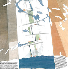
This Map (and text) is from the 1st price project in Nordhavnen,(1st face), Copenhagen: Excentral Park - Edge Dynamics, which we did together with 70°N and a panel of experts.
Monday, June 22, 2009
Bridging and Branding // Nordhavnen // The Map Collection
Labels: in english, landscape, The Map Collection, urbanism
Subscribe to:
Post Comments (Atom)


No comments:
Post a Comment