For the first time, leading international researchers have made an overview of snow and ice melting globally. The conclusions show that the snow-and ice-covered areas will disappear faster than previously thought. - This is frightening news. World leaders must now work out a solution that ensures dramatic cuts in greenhouse gas emissions. It's not a lokal issue - its a global issue.
Today two alarming reports about climate change in the cryosphere has been presented at COP 15. Al Goore and Jonas Gahr Støre presented the report Melting snow and ice-A call for action (made in Tromsø) and Dorte Dahl Jensen presented the report The Greenland Ice Sheet in a Changing Climate.
At the pressconference with Denmarks’s Minister of Foreign Affairs Per Stig Møller and Greenland Premier Kuupik Kleist, Norway’s Minister of Foreign Affairs Jonas Gahr Støre, and researcher Dorte Dahl Jensen , it came up a really interesting discussion about Greenlands special position, located by the melting ice in a historical moment where they need to build up their own economy in order to get political freedom.
Kuupic Kleist, speech.
Monday, December 14, 2009
Environmental and Political Changes in the Cryosphere
Sunday, December 13, 2009
THERE IS NO PLANET B

Not to inform ourselves about the progress and setbacs in Copenhagen is no alternative. You can follow the climate negotiations at cop webcast, and read continiously uppdates at cop15.dk/news.
At klimaforum09, the alternative climate congress, the voices that are not heard in the official congress gather, share ideas, and creates strategies for a sustainable future. Here comes the environmental movement in the North, together with indigenous people from the South, so this can be a turning point.
Friday, December 11, 2009
xmas calendar window

As a litle christmas calendar gift we prestent Ivers homage to Miyazaki, his films has followed our family almost from the start...
from Ivers deviantart profile:
First of i just want to say thank you to Hayao Miyazaki and Studio Ghibli, for creating all them wonderful movies. I've literally grown up with the Ghibli collection. And i've always loved it, from when i saw Spirited Away in first grade in year 2000, to now. And i think that it was the Miyazaki movies which awoke my interest in drawing. Anyway, here's a list of the characters i drew (and failed miserably) and the movies they belong to:Chihiro - Spirited away, Patzu - Castle in the sky, Sheeta - Castle in the sky, Kiki - Kiki's delivery service, Satsuki - My neighbour Totoro, Mei - My neighbour Totoro, Sen - Princess Mononoke, Porco - Porco Rosso, Nausicaa, Nausicaa of the walley of the wind, Sophie - Howl's moving castle, Totoro - My neighbour Totoro, Robot - Castle in the sky. And then again, thank you Miyazaki! - Pivers
Sunday, December 6, 2009
Vulnerability
"We know too little, and it does not exist. We know too much, and it does not exist. To write is to draw what exists out of the shadows of what we know."
(Translated from Karl Ove Knausgård's book Min Kamp - bok 1, page 192. "Man vet for lite, og det finnes ikke. Man vet for mye, og det finnes ikke. Å skrive er å trekke det som finnes ut fra skyggene av det vi vet." )
The following text is written with the possible vulnerability of the event taking place in Copenhagen in December, the United Nations Climate Conference in mind – be aware.
(read more)
Thursday, December 3, 2009
Tandi with news from Sendai

Monday, November 30, 2009
Vindstille eller storm i København?
![]()
For å sitere Naomi Klein (i Dagbladet 18. november): «Hvis klimaet var en bank ville det bli reddet – ikke overlatt til markedets brutalitet». Det betyr ifølge henne at en global ulydighet, en ny type motstand må vokse ut av en mulig København-tristesse.
Friday, November 27, 2009
D&U ONLINE PAPERS // mosaic::reading
mosaïc::reading - the city as biotope is a master studio at Bergen Arkitektskole run during the autumn term 2009 by Gisle Løkken, Magdalena Haggärde, Kjerstin Uhre and Knut Eirik Dahl. Under the themes of new hierarchies, imbedded information, elasticity, dynamic of small cultures, points of departure, vulnerability and charging the landscape with new energy different aspects, ideas and possibilities of planning have been discussed and discovered - at the school in Bergen, on study trips to Malmö and Paris and on the blog cityasbiotope. The blog have grown throghout the semester with the students’ work, the presentation of new themes and comments Here, in this little textbook: mosaic::reading, the collection, we have gathered the introduction texts for each theme.
GL, MH, KED and KEU
Tuesday, November 10, 2009
CONDITIONS

The jury in Öresund Visions 2040 consisted of leading academics, artists and young architects. The jury in the Nordhavnen competion was more of a political stronghold including lord mayor of Copenhagen Ritt Bjerregaard and mayor Klaus Bondam among others.
So, it is possible to say that together the statements, signals and terminology of these two competions from the Norwegian team are accepted as highly relevant views on the future Öresund, in time to come. Both by the academic and the political environment in the
region – in theory.
The Nordhavnen experience
Nordhavnen is part of an extension strategy for Copenhagen with 40 000 residents and
40 000 workplaces on an industrial landfill out into the seascape of Öresund.
The competition program was ambitiuos on all levels of sustainability, bordering on images of the ideal city, as the political and planning forces of Copenhagen see it to day, prolonged into an unknown future. The fact that Copenhagen hosts the United Nations Climate Conference in December 2009 (COP15) informed the program with the ambition that Nordhavnen can be presented here as a world leading Copenhagen example.
The jury said this about Excentral Park – Edge Dynamics: “The jury believes that the entry presents, through its strategies, a genuinely new perception of a structure plan and consequently sets new horizons for urban development”.
With this enlightening jury comment the Norwegian firms entered a second phase with the two Danish winners as opponents. During three months, in continuos dialogues with a board of representatives from the Copenhagen authorities, City and Harbour and three former jury members, the concept was tested related to a series of questions from this board, and the jury.
After these explorations of the concept the Norwegian firms recieved a short note from the board that one of the Danish groups was chosen as advicers for the planning process in Nordhavnen. Up to now the Norwegian team has not seen any extensive response of any kind on this second step.
Uncertain futures and public debate
The team has lately been debating their concept in the context of both the Danish and Swedish associations of Landscape Architects. Before a very vibrant discussion on their Edge Dynamics concept took place at the conference World in Denmark this summer, the Norwegian team asked Kent Martinussen, leader of DAC and part of both the jury and the board in Nordhavnen, why this enormous extension of Copenhagen is nearly not visible in the media. He said that there are three reasons. The first is that COP15 is dominating all media, nothing else makes the headlines. The second is that nothing is discussed before the building cranes are in Nordhavnen, the third is that strong political forces goes for a freezing of the whole Nordhavnen concept, in a time of financial crisis.
An experience with both competitions in the region is that there to a very little extent is an offensive attitude from the inviting parties towards the media. No press conferences and debates of any importance, no debating arrangements around the exhibitions and so on.
If and when the team and the Edge Dynamics concept will reappear in the Nordhavnen context is yet unknown.
To be continued….
Conditions will present the Norwegian team’s Öresund findings in an upcoming issue. For the moment The Nordhavnen concept is exhibited in Hamburg, and the team, 70°N and D&U, is now following up their Öresund encircling in a master studio at BAS, possibly waiting for the next challenge in the Öresund Metropole.
Friday, October 2, 2009
Mind Field Lund // Mosaïc::Region // The Map Collection

Wednesday, September 30, 2009
First session of the Norwegian Europan 10 jury and Ellen van Loon in lecture

160 projects in three Norwegian cities is to be evaluated by a very interesting Norwegian Europan 10 jury, the 1.and 2. of October.
In the afternoon Friday the 2. the jury member Ellen van Loon, partner in OMA, will give a lecture at the 0047 gallery in Oslo, followed by a conversation with the president of Europan Norway, Knut Eirik Dahl.
Scandinavian conversations on the Malmö dynamics at SLU Alnarp

Last week we were revisiting the Øresund region with our mosaïc mindset and 19 architect- and landscape architect students from Bergen School of Architecture. After studying Malmö in the virtual world for two weeks, under the headlines of New Hierarchies and Imbedded Information, it was time for us and the students to enter this field of exploration, walk the streets, meet the people and hit the dynamics and the patterns that connects.... An in depth research into the imbedded information of Malmö.
On Thursday we had conversations with prof.Carola Wingren and her students from the landscape architect department at the Swedish University of Agricultural Sciences in Alnarp.
The journalist Peter Sylwan and the head of urban straties in Malmö, Johan Emanuelson, guided us through the possible future agricultural landscape and into the growing city.
Carola Wingren's master course is dealing with how Malmö can meet future challenges from sea level rise. SLU Alnarp is set in a large, old park with thousands of species plants and trees north of Malmö. We rounded up this fine day with a walk in this beautiful park.
The Malmö findings will be posted at city as biotope under the label Elasticity.
Friday, September 25, 2009
World Wide Views
I morgen, 26. september arrangeres verdens første globale borgerhøring. Da samles folk i 46 land på alle kontinenter for å uttale seg om klimautfordringer og aktuelle klimatiltak. World Wide Views
Tuesday, September 1, 2009
master studio and blog

mosaïc::reading - the city as biotope is a master studio at Bergen School of Architecture run during the autumn term 2009 by Gisle Løkken, Magdalena Haggärde, Kjerstin Uhre and Knut Eirik Dahl. Under the themes of new hierarchies, imbedded information, elasticity, dynamic of small cultures, points of departure, vulnerability and charging the landscape with new energy different aspects, ideas and possibilities of planning will be discussed and discovered - at the school in Bergen, on study trips to Malmö and Paris and on the blog city as biotope
Tuesday, August 4, 2009
EnergyMap // link // The Map Collection
 EnergyMap is the national Danish internet portal for energy and climate related solutions. On Energymap Danish companies, organisations, institutions and public authorities are given the opportunity to present their work and ideas on technologies and programmes that may help combat climate change and improve energy-efficiency. Users of EnergyMap are invited to explore the solutions, cases, projects and events presented on the portal. Many of the featured sites are open for visitors and many also offer investment opportunities.
Explore EnergyMap here
Wednesday, July 29, 2009
Greenhouse Gas Emission Data on Google Maps // link // The Map Collection

The United Nations Framework Convention on Climate Change secretariat has cooperated with Google and the Danish government as hosts of COP 15 to display official UNFCCC greenhouse gas (GHG) emissions data for Annex I Parties using Google Maps. The Maps are now online and can be accessed on the UNFCCC GHG data interface. Users can select on a world map total national GHG emissions/removals as well as emissions/removals from various sectors; absolute numbers (in Gg CO2 equivalent); or relative changes in emissions (in per cent compared to the base year level). Information is provided for all sectors (such as energy, agriculture, etc) and for the major sub-sectors (such as transport within the energy sector). By gas, the data cover aggregate GHGs, CO2, CH4, N2O, SF6, HFCs and PFCs.
Link to the world map total national GHG emissions/removals
Saturday, July 4, 2009
Seismograph City

The Exhibition is a part of Hamburger Architektur Sommer, the programme can be downloaded here: RAUM IN DER ZEIT - Hamburg im Fluss
The universal city defines itself not only as the catalyst of cultural, social, economic and ecological processes, but also as the seismograph of global developments. Never before has there been such consensus between politicians and the public on the question of how we can innovatively and constructively improve our living environment. Given global challenges to develop sustainable strategies in architecture and urban design, the architectural profession assumes a significant role and responsibility. This exhibition and catalogue present a diverse spectrum of buildings in various stages of development and completion as well as visionary designs which address sustainable strategies in the context of current architectural and urban developments worldwide. Selected projects provide an exciting insight (not overview) into current planning in the city of Hamburg, as well as a fascinating and rather surprising collection of projects, designs and visions which excite our imaginations, give us strength, motivation and which hopefully inspire us to further examine themes of sustainability.
org Freie und Hansestadt Hamburg, Behörde für Stadtentwicklung und UmweltMo bis Sa 11-18 Uhr, Fr 11-20 Uhr@ Hamburg, Deichtorcenter, Oberbaumbrücke 1
Friday, July 3, 2009
PLAN # 3-4 2009
 Three of our projects are mentioned in the latest issue of PLAN - Tidsskrift for samfunnsplanlegging, bolig og byplan og regional utvikling.
John Pløger refers in his Article, Ambivalens og etos - forskjeller og likheter i byplanlegging i Norge og Danmark, to The Game of Tromsø and The Year of Urban Development (BYÅR05) as some of the more "spectacular" experiments in norwegian planning, with reference to our paper Openness and experiment.
Hanne Bertnes and Aasne Haug uses the Nordhavnen competition as a case in the article Et møte med dansk planmiljø.
"Hvordan sikres intensjonene i en god plan? Er det i styrkeforholdet mellom offentlig ansvarlighet og private investorer man finner svaret, eller er det mer i prosessen og mindre i selve svaret?
De tre vinnerne etter første runde i Nordhavnen hadde ulike svar på akkurat dette. Mens de to danske prosjektene la opp til en "tradisjonell" planstrategi der planen definerer de fysiske strukturer, satset det norske vinnerbidraget på en prosessbasert planstrategi, der viktige offentlige strukturer defineres, men der fremtidens fysiske omgivelser defineres suksessivt med utviklingen. Denne tankemåten erkjenner at vi ikke vet hva fremtidens samfunn trenger, men er samtidig mer krevende for planleggere og utviklere som ønsker forutsigbarhet."
"How to secure the intentions of a good plan?
The three winning concepts in the Nordhavnen competition had different answers to this question. While both the danish projects presented a 'traditional' planning strategy where the plan defines the physical structures, the norwegian winning proposal went for a process based planning strategy, where important public structures are defined, but where the physical surroundings of the future are defined successively with the development. This thinking recognizes that we do not know what tomorrow's society needs, but is at the same time more challenging for planners and developers who wish predictability."
Ny milepæl på veien fra Rio? // ARKITEKTNYTT
Jan Carlsen har intervjuet Knut Eirik, Marius Nygaard og Harald N. Røstvik om Cop 15. med utgangspunkt i Excentral Park - Edge Dynamics.
– Det er trolig at byenes skjebnefellesskap får spesiell omtale på konferansen, et nytt sivilisasjonsprosjekt som inkluderer medvirknings- og demokratiaspektene. I tillegg kommer alternative energiformer garantert til å bli viktige, mener Dahl
...
Arkitekt Marius Nygaard, førsteamanuensis ved Arkitektur- og designhøgskolen i Oslo, har deltatt i professor Bente Klevens lærerteam for studentene på andre årstrinn.
– Kurset brukte konkurranseutkastet til 70°N arkitektur og Dahl & Uhre for Nordhavnen i København som byøkologisk rammeverk for oppgaven, forteller Nygaard. – Studentene tegnet et besøkssenter med biologisk mangfold og økologi som tema. Slik ble studentenes arbeid indirekte knyttet til oppkjøring mot COP 15-konferansen.
...
...vår profesjon har makt til å forandre mye. Derfor må arkitekt- og byplanutdannelsen styrkes med hensyn til bærekraft. Politikerne klarer ikke jobben alene – det demonstrerer de hver dag. Naturen kommer til å skake oss voldsomt hvis vi ikke ser alvoret i klima- og energisituasjonen, avslutter arkitekt Harald N. Røstvik.
Les hele intervjuet her: Ny milepæl på veien fra Rio? ARKITEKTNYTT
Se også: ARKITEKTNYTT om æresprisen til Knut Eirik
Thursday, July 2, 2009
Red den intakte natur før alt andet // Link // Kronik - Politiken
Rasmus Ejrnæs, seniorforsker ved Afd. for Vildtbilogi og Biodiversitet, Aarhus Universitet og Hans Henrik Bruun, docent ved Ekologiska Institutionen, Lunds Universitet har skrevet en viktig og innsiktsfull tekst om sårbarhet og naturforvaltning. Her kommer noen utdrag fra kronikken:
"....Omsat til naturforvalterens sprog lyder brandmandens lov således: Først må man redde den natur, som endnu ikke er ødelagt. Dernæst gælder det om at fjerne de negative påvirkninger fra den øvrige natur, som er under ødelæggelse. Når tilstanden i den bestående natur er gunstig, kan det give mening at etablere ny natur.Desværre har denne enkle lov aldrig vundet indpas blandt beslutningstagere højere oppe i systemet. Om det skyldes at beslutningstagerne ikke kan overskue den vilde naturs kompleksitet, eller ganske enkelt foretrækker at klippe snore ved indvielser af ny natur, kan være svært at afgøre. Men det er et spørgsmål værd, om de begrænsede midler, der afsættes til naturformål, bruges omkostningseffektivt, når brandmandens lov vendes på hovedet....
....Næringsstofferne forvilder sig ud i naturen fra landbrug og afbrænding af fossile brændstoffer. Kvælstof kommer via luften, og kvælstof og fosfor transporteres også ud i naturen med drænvandet fra de dyrkede marker. Det er velkendt, at næringsstofferne slukker lyset og skaber iltsvind i søer, fjorde og lavvandede havområder, men næringsstofferne ødelægger også levestederne på land.
Effekten kan synes knap så dramatisk på land. Her ligger fuglene ikke med bugen i vejret og gisper efter luft, men tabet af nøjsomhedsplanter, sommerfugle, vilde bier, rensdyrlaver og svampe er ikke desto mindre voldsomt. De vilde dyr, planter og svampe har aldrig tidligere i evolutionens lange historie været udsat for et lignende tæppebombardement med næringsstoffer....
....Vi vil vove den påstand, at det frem for at etablere ny natur på dyrkede marker og gødskede enge vil være langt mere omkostningseffektivt at:
• Udvide arealet med urørt skov i Danmark ved at standse den forstlige drift i eksisterende skove.
• Sikre græsning af eksisterende naturområder i Danmark, som i dag henligger uden græsning, både skove og lysåbne naturtyper.
• Beskytte eksisterende naturområder mod næringsforurening ved at udlægge dyrknings- og gødningsfrie bufferzoner i kanten af marker, hvorfra der i dag foregår udvaskning til overdrev, heder, moser, skove og enge. Ikke bare helt nede ved selve vandløbet, men oppe i kanten af marken, hvor ådalen, kystskrænten eller strandengen begynder.
• Genskabe det naturlige vandkredsløb i eksisterende naturområder ved at sløjfe dræn og grøfter og beskytte eksisterende natur mod vandindvinding...."
Knut Eirik kommenterte teksten slik: Interessant tekst! Kjenner dere kunstneren Christos prosjekt der han la rød duk rundt hver av øyene i et arkippelago utenfor Florida: Kan jeg oppfatte deres strategi dithen at dere lanserer en beskyttelsesone rundt den eksiserende natur dere vil forsterke? Nærmest som et naturarkipelago i et jordbrukshav, og at dette er en slags hovedstrategi?
Les hele kronikken her: Politiken.dk!
Monday, June 29, 2009
'scape // Adaptive seaward extension for Copenhagen

The duch architect and writer Joren Jacobs has made an article about the planning strategies in our Nordhavnen project, Edge Dynamics in 'scape 1# 2009 .
Friday, June 26, 2009
The aftermath of COP 15 // Nordhavnen // The Map Collection

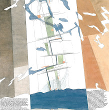
This Map (and text) is from the 1st price project in Nordhavnen,(1st face), Copenhagen: Excentral Park - Edge Dynamics, which we did together with 70°N and a panel of experts.
Thursday, June 25, 2009
Pre COP 15 // Nordhavnen // The Map Collection

This Map (and text) is from the 1st price project in Nordhavnen, (1st face), Copenhagen: Excentral Park - Edge Dynamics, which we did together with 70°N and a panel of experts.
Tuesday, June 23, 2009
Kronikkenes by II - Tromsø 2040 #3

"Den måten Norge håndterte oljerikdommen på er unik i internasjonal industrihistorie. Når tyngdepunktet for oljeutvinningen nå flyttes nordover og når teknologifokus gradvis flyttes over mot miljø og fornybar energi; klarer da politikerne å vise samme handlekraft? Kan våre barn, når de om 30 år ser seg tilbake, si at Norge igjen skrev et stykke industrihistorie - denne gangen i nord?"
Serien Nord-Norge 2040 fortsetter på kronikkplass i Nordlys...
Monday, June 22, 2009
Bridging and Branding // Nordhavnen // The Map Collection

The competition of Ørestaden in 1994 can be seen as Copenhagen’s urban answer to the Öresund Bridge project. The program for Ørestaden was as ambitious as for Nordhavnen, but in a different time. Here the ambitions of Copenhagen as an important city in a European economic picture were dominant (new Docklands etc.) The ideal world of Ørestaden, as a line of growth out towards Amager’s periphery, have not however been sustained in dialogue with the larger image of the city. More interesting urban developments have taken place in other parts of Copenhagen, and ideas and ambitions have disintegrated in Ørestaden’s era.
Nordhavnen has now been designated as the place for seven present ambition’s criteria summed up as ‘The Sustainable City of the Future’. As in Ørestaden a linear direction of development has been chosen, but this time directly into the Øresund Strait, functioning as a game board for these ambitions. The program’s statement is that all ambitions that have not taken place other places will happen here, - not unlike the ‘best of all’-programs for Ørestaden.
This Map (and text) is from the 1st price project in Nordhavnen,(1st face), Copenhagen: Excentral Park - Edge Dynamics, which we did together with 70°N and a panel of experts.
Sunday, June 21, 2009
ARKITEKTURPOLITIKK // fra Tromsøsamtalene
 I to dager har Kjersti Nerseth, NALs president vært i Tromsø. En dag med byens arkitekter og en dag med byens administrasjon og politikere.
Temaet er regjeringens kommende arkitekturpolitiske handlingsplan. Spesielt engasjerende var møtet med leder for byutviklingskomiteen Eduardo da Silva(AP), byplanssjef Erik Øwre og arkitekter fra Tromsø, Bodø og Mo i Rana. Nerseth viser til Tromsø som forbilde nasjonalt med de to store byutviklingsprosessene Spillet om Tromsø/1995 og Byutviklingens år/2005.
En intens og flott diskusjon oppsto rundt den siste prosessen som jo var igangsatt av politikerne, men som ble ledet og gjennomført med en ledelse på utsiden av systemet.
Se visepresident i NAL, Gisle Løkken sin aviskronikk i tidligere post på bloggen.
Vi syns byplanssjefen oppsummerte drøftelsene på en fin måte da han sa: ”Kanskje det er på tide å lansere noen helt nye ambisjoner for byen”. Mer om dette senere….!
I møte med ordfører Arild Hausberg og kulturråd Irene Valstad Simonsen kom det interessante i at Tromsø kommunes parole om 100% barnehagedekning faktisk har ført til en rekke fine prosjekter som er prisbelønnet og som har fått stor internasjonal oppmerksomhet. Altså et dristige politiske signaler får arkitekter til å ta seg helt ut og bli oppfinnsomme. Avisa Nordlys samlet deltakerne ute i solen og trykket lien spalte dagen etter. Vi synes presidentens Norgesturne er flott, og er glad for den innlevelse hun viser. Spesielt gleder vi oss til redaktøren av Arkitektnytt kommer med et helt nummer om denne dramatiske krysningen gjennom landet.
Saturday, June 20, 2009
den nasjonale konferansen om landbruk, mat, energi og klima
State of the art klimapolitikk, forskning og tiltak i Norge? Mat og Landbruksdepartementet har nylig arrangert en konferanse på Gardermoen hvor forskere og politikere la fram målsetninger og forskningsresultater. Vi hadde lyst til å dra… ikke anledning, men nå kan vi alle gå igjennom powerpointpresentasjonene som er lagt ut på M&Ldep’s debattsider om landbruk og klima.
"Landbruk - en del av løsningen" -den nasjonale konferansen om landbruk, mat, energi og klima på Gardermoen 2. - 3. juni 2009
Matforsyning, forbruk og klima, medarrangør Statens landbruksforvaltning
Trebruk og trearkitektur, medarrangør Innovasjon Norge
Bioenergi og småkraft, medarrangør Norsk senter for bioenergiforskning
Klimaeffekter - utfordringer og muligheter, medarrangør Veterinærinstituttet og Bioforsk. (kilde: e-varsling fra Kommunal og regionaldepartementet...som anbefales, der kommer det mye interessant info)
se presentasjonene her
Friday, June 19, 2009
ARKITEKTURPOLITIKK
 NAL-president Kjersti Nerseth besøker alle lokalforeningene i NAL i løpet av 2009. Hun var her i går og i dag sammen med redaktør i Arkitektnytt, Grete Kristin Hennissen og direktør i NAL, Pål Stephensen for å samtale med politikere og arkitekter. I morgen legger vi ut en liten tekst om Tromsøsamtalene... Regjeringa legger i løpet av sommeren 2009 fram en handlingsplan for arkitektur i Norge. Gisles Kronikk i Nordlys setter den lokale arkitekturpolitikken i perspektiv.
Wednesday, June 17, 2009
Byplanens dilemmaer // Fagseminar // UIA

”Det er ikke nok at tro, at vi kan genopprette en balance. Det bliver nødvendig med en løpende og dynamisk tilpasning til de dramatiske klimaændringer. Hvordan udvikler vi vores civilisation under disse skiftende vilkår?
Byen kan kun blive løsningen via borgernes deltagelse. På den måde kan der ske en professionalisering og demokratisering, hvor borgerne i de sociale nættverk, virksomheder og bymiljøer spiller sammen som urbane fællesskaber. Det er i disse urbane fællesskaber
- der kan transformere seg sammen med byen – at tilpassningen til klimaændringerne kan foregå dynamisk og hurtig nok”.
På UIAs fagseminar 15. og 16. juni annonserte jeg at dette utsagnet fra Peter S. Jørgensen i Weekendavisen skulle være mitt point of departure. Som sagt så gjort. Sammen med en nytenkning rundt byutviklingens år avstedkom dette nogle flotte diskusjoner. Jeg viste kartet fra utstillingen Tromsø X-Files i 2005 der alle de nye prosjekter antastet byen nærmest som røde hunder i boligboomens epoke.
Byplanssjef Gunnar Stavrum i Kristiansand la etterpå fram en sjelsettende, bevegelig powerpoint-framstilling av hvordan 37 prosjekter nå på tilsvarende måte bombarderer Kristiansand i dag. Og han spurte oss med hånden på hjertet; ”hva gjør jeg med dette!”
Samtidig viste han en slående framstilling av hvordan planetaten nesten aldri var de som initierte og startet prosjekter, og at de altså nærmest kom i offerets posisjon – sterkt!
Journalisten fra Fædrelandsvennen som var engasjert tilstede begge dagene grep jo straks tak i at Tromsøs oppdagende og avdekkende metoder burde kunne tilflyte Kristiansand. Altså at det å stille ut er åpne opp.
Mens utbyggerne i Kristiansand tilsynelatende har lite sidesyn til en verden i endring, så debatterte foreleserne på seminaret dynamikk, endringshastigheter og nye og overraskende samarbeidsformer i bylandskapet på friskt vis.
Professor Roy T. Eriksen utviklet sin tekst i siste nummer av Marg, Vandringer i et ruinlandskap, anvendt på Kristiansand og ble en viktig referanse for flere av de etter- følgende foreleserne. Etnologen Kirsti Mathiesen Hjelmdahl fra Agderforskning la fram prosjektet profesjonalisering av kulturnæringene på Sørlandet på et utrolig innlevd vis. Understrømmer som kan få stor betydning for Agderbyenes utvikling. Sensitivitet, dynamikk, hastighet og tilstedeværelse ble lansert som viktig byterminologi av henne. se Fædrelandsvennen
John Pløger var gledelig tilstede med Lefebvre og innom Marianne Skjulhaugs tekst i Marg, Innviklede forbindelser som søker en form.
Gjennom begrepene den kroppslige by, den relationelle by, den narrative by og den meningsfulle by utfoldet han et bilde av hverdagslivet mellom det tenkte, planlagte, og det levde. Han karakteriserte ”handlingen som kontinuerlige brudd med signaler, normer og konvensjoner”.
Kveldseansen i Håndverkerens mørke kulisser med tema Toleranse, litteraturen og byen vår en flott opplevelse med tente, vel forberedte innledere. Paal-Helge Haugen fikk sitt Marg og var meget glad for det.
Knut Eirik
Tuesday, June 16, 2009
Miljøstatus 2009 viser miljøutfordringene
Utslipp av klimagasser og global oppvarming er vår tids største miljøutfordring. Situasjonen er alvorlig for naturmangfoldet, på grunn av klimaendringer og andre trusler. Det viser den nye publikasjonen Miljøstatus 2009, som gir en tematisk og helhetlig oversikt over miljøutfordringene i Norge. (kilde:dirnat)
Last ned miljøstatus 2009 her
Monday, June 15, 2009
Why Here? // The Map Collection

This map was our starting point for an investigation on a city development in Stavanger in 2000. It led, together with Paolo Viganos lecture in Cordoba (Europan, 2003) to the text ”Topografiske attraksjoner” (topographical attractions), published in Arkitektnytt in 2003.
In the spring 2010 we will revisit the study field of Jæren through the course, Appearing and Disappearing Landscapes, which is part 2 of AHO's "Research on the Norwegian Landscape". The course is an inter-Nordic cooperation between the AHO and Forests and Landscape at Copenhagen University. Jæren is a region that today has the largest urban growth in Norway after Oslo. The region, which is the centre of oil development in Norway, is now entering into a new phase, causing both landscape and urbanity to be in need of reinterpretation. The course will establish recognition on the larger scale that will affect knowledge built up during the course work. The UN climate conference, COP 15, in December 2009 will send out signals concerning this larger scale.
The Course is planned as a discourse between landscapes and urban conditions that range from the smallest biotope to the larger future image. Students will throughout the semester work on individual projects as experiments in the relationship between different territorial contexts and urban strategies; this will entail both a smart and innovative cartography and conceptual design projects.
Sunday, June 14, 2009
BYEN UNDER PRESS

Uroen som ligger som en undertekst i alle artiklene i siste nummer av Marg framkaller denne headingen; byen under press. Peter S. Jørgensen sin tekst New York – retten til byen beskriver hvordan nye bevegelser og understrømmer i megabyen er i kontinuerlig dialog og konflikt med administrative virkeligheter og planleggingsteser. I Weekendavisen nr 24, 12. juni har han besøkt utstillingen Fremtidens arkitektur er grønn. Arkitekturens grenser II på Louisiana.
I artikkelen Framtiden er uvissen utvikler han sine New York oppdagelser slik, etter å ha sett MITs klimaadvarsler på utstillingen:
”Det er ikke nok at tro, at vi kan genopprette en balance. Det bliver nødvendig med en løpende og dynamisk tilpasning til de dramatiske klimaændringer. Hvordan udvikler vi vores civilisation under disse skiftende vilkår?
Byen kan kun blive løsningen via borgernes deltagelse. På den måde kan der ske en professionalisering og demokratisering, hvor borgerne i de sociale nættverk, virksomheder og bymiljøer spiller sammen som urbane fællesskaber. Det er i disse urbane fællesskaber
- der kan transformere seg sammen med byen – at tilpassningen til klimaændringerne kan foregå dynamisk og hurtig nok”.
Universitet i Agder er midt inne i sitt forskningsprosjekt City and Tolerance.
15. og 16. juni arrangere UIA et fagseminar med overskriften Byplanens dilemmaer.
Knut Eirik foreleser på dette seminaret under seminaroverskriften hva kan byplanleggingen tilby og med forelesningstemaet Byen under press som drar noen linjer videre fra det Peter S. Jørgensen åpner for. Heri inkludert noen nye betraktninger rundt Byutviklingens År 05.
Her møter han bla Roy T. Eriksen som foreleser om Vandringer i et ruinlandskap som er en utvikling av hans tekst i siste nummer av tidsskriftet Marg.
Til Kristiansand kommer også Jonny Aspen som stiller spørsmålet trenger vi byteorien og John Pløger som utdyper hva som gjør byrom til samhandlingsrom.
Toleranse, litteraturen og byen er temaet for en kveldsforestilling i Håndverkeren den 15. der John Pløger, Paal-Helge Haugen, Torild Wardenær og Knut Eirik Dahl skal skape noen åpninger.
Friday, June 12, 2009
Resistance // The Map Collection

Each element, every trace describing the appearing manufactured and spiritual landscape is to be considered as resisting change, interposing processes which resists and reformulate actual interventions in space.
A canal or a lake can thus fashion a word of ideas for what is to follow. A planted forest will after 20 years demand respect and care. An area in which all of nature is subject to change during 30 years will by virtue of that change draw attention to itself and become an alternative to all development strategies. Our concept entails exploring how such an incipient landscape shapes its capacity for resistance, in other words how it is shaped in time.
We made this map over Ørestaden in 1994 as a part of The Magic Carpet.
Thursday, June 11, 2009
WONDERFUL DAYS


It has been raining now for ages it seems. But in early May we had wonderful days when the arctic spring was trying to get a hold on Strandkanten. We have been living here in our own project for a year now- as an experiment- in a random choice of one of the apartments we have designed. It has been a positive experience. We’re also happy about the landscape project, which are under completion these days, made by Aurora Landscape in collaboration with Ljusarlitektur, 70°N and D&U. Landscape architect Anita Veiseth has done a great job in facilitating the project for teenagers. The young boys, 13-19 years old have already made this landscape their spot in Tromsø. They are hanging out, playing football-games, basket ball and of course skating. Through the Game of Tromsø, we discovered the urban potential of the area. In 2000, as a part of a political process, we reworked the master plan for Strandkanten in collaboration with 70°N and Code.
Sunday, June 7, 2009
The Northern Norway Architecture Award

Knut Eirik Dahl has recieved the Northern Norwegian Architects Association's Honour Award for his enduring efforts to increase the understanding for -and raise the quality of- our urban environments. .
The two architectural awards for 2009 were given to:
- Ungdomshuset Straumanstua in Lofoten by Jarmund/Vigsnæs
- The rehabilitation of Hamningberg in East Finnmark.The project has been a collaboration between Båtsfjord, Vardø, Finnmark Fylkeskommune, Riksantikvaren and Statens Vegvesen.
The prize ceremony for the Northern Norway Architecture Award was in Tromsø at NAF's annual meeting, june 5.
Friday, June 5, 2009
World Environmental Day 2009
Today it is World Environmental Day! On the WED homepage you can get the daily do something TIP, join the Climate Heroes and more...
Melting Ice // The Map Collection

This map from 2006, which we made for the arctic cities exhibition at the 10'th architectural Biennale in Venice together with a great team, shows the early estimates for the meltdown of the ice cap. Today we know for a fact that the process is going much faster. Two years later Jan Gunnar Winther, Director of the Norwegian Polar Institute in Tromsø, stated: ”The summer of 2007 was a record year climate-wise: the ice in the Arctic was down 20% from the previous record year in 2005. The September Ice in 2007 was historically small in scale and one thus expects a new record low in 2008. Mathematical climatic models has not been able to take into account these fast changes. They don’t reproduce reality well enough.” The climate change sets new conditions for spatial planning. Read more in Appearing and disappearing Landscapes in On Site, the book will be launched at the Architekturforum in Zurich tomorrow.
related link: Earth Observatory // World Of Change
Tuesday, June 2, 2009
Many Strong Voices // COP 15
Yesterday we got two interesting links at Cicero's news update service on climate change: “Climate change in the Arctic is a human issue, a family issue, a community issue, and an issue of cultural survival. The joining of circumpolar peoples with Pacific Island and Caribbean States is surely part of the answer in addressing these issues. Many small voices can make a loud noise. As we melt, the small developing island states sink.”
Sheila Watt-Cloutier, 2007 Nobel Peace Prize Nominee
Many Strong Voices
FNs klimapanels siste hovedrapport omtaler Arktis og lavtliggende øyer i Karibien, Stillehavet og andre steder som noen av de mest sårbare områdene for klimaendringer. Alliansen Many Strong Voices skal jobbe for en internasjonal klimaavtale med omfattende globale utslippsreduksjoner.
Utsatte grupper hever stemmen
Monday, June 1, 2009
Manhattan Transfer // The Map Collection
![]()
Along the ridge of Tromsø Island there runs a band of continues woodlands – the Tromsø Common – which in size and extension corresponds to that of Central Park in New York. Back in 1994 we superpositioned Manhattan on this map over the Tromsø Island. Tromsø was experiencing an explosive urban growth, and it was necessary discuss the lokal attitude towards nature as an unlimited resource. The Tromsø common vas already changing from being nature to become a park. 14 years later the map still has actuality in the urban discource i Tromsø - it has proved to be a valid statement.
The fact that we have an urban park of an international format is the most visible urbane trait in Tromsø that necessitates a further urbanisation. The Green Line bind all the city areas together, in winter functioning almost as a metro for cross-country skiers and families on a hike.
Skating in Central Park
The United States of Barents // link // The Map Collection

Web-fiction, based on the performance at PAN-BARENZ
Artist/musician Amund Sjølie Sveen speaks to us back from 2036 and tries to analyze the changes that have lead to establishment of the USB and proves that the opening of a new IKEA-store in HaparandaTornio in 2006 is a major event in the history of the Barents Region. What happens when the region experiences a potential change from periphery to center? Why are we all talking English to each other? Welcome to the brave new world of the United States of Barents!
Friday, May 29, 2009
D&U ONLINE PAPERS // GUEST // Peder Agger and Jesper Brandt // The Dynamics of Small Biothopes in Danish agricultural landscapes


The Danish biologist Peder Agger and the geographer Jesper Brandt, published in 1986 the result of 10 years of research, analysis and wanderings through the text The Dynamics of Small Biothopes in Danish agricultural landscapes. It describes a landscape under pressure, it raises the question about the vulnerability of the landscape, about relationships, and describes this as voices that speak to us about survival. It is a classic text in landscape research and made a strong impression on us when we found it on the web two years ago. Peder Agger is Chairman of the Danish Council of Ethics and professor at the Department of Environment, Technology and Social Studies, Roskilde University, Denmark. Jesper Brandt is Professor at the Department for Geography and International Development Studies, RUC and at ENSPAC (Department of Environmental, Social and Spatial Change). link to: The Dynamics of Small Biothopes in Danish agricultural landscapes
Thursday, May 28, 2009
Mapping the Seabed // MAREANO // link // The Map Collection

This screenshot of the MAREANO map viewer shows the area of hydrographic survey data at the Norwegian continental shelf, an area bigger than the Norwegian mainland. On the MAREANO map wiever you click into registrations, images and videos of the seabed.
Global heating increases the pressure on coastal areas and ocean zones, the seabed itself and the quality of the ocean areas are at stake – the resources here constitute the world’s future "granaries" and "larders". It is the mapping and change of this seascape that now appears as the big challenge – a future and appearing landscape undergoing a dramatic and complex process of change. This environmental mapping’s collision with the mapping of fossil resources can from hegemonic milieus be seen as a disturbing mapping.
MAREANO maps depth and topography, sediment composition, biodiversity, habitats and biotopes as well as pollution in the seabed in Norwegian coastal and offshore regions.The MAREANO Programme aims to provide answers to questions such as: How is the seascape of the Norwegian continental shelf? What does the seabed consist of? How is the biodiversity distributed on the seabed? How are habitats and biotopes distributed on the seabed? What is the relationship between the physical environment, biodiversity and biological resources? How are contaminants stored in sediments? MAREANO is coordinated by the Institute of Marine Research, in collaboration with the Geological Survey of Norway and the Norwegian Hydrographic Service.The Programme is financed by the Ministry of Fisheries and Coastal Affairs, the Ministry of Environment and the Ministry of Trade and Industry via contributions from the National Budget.
Se også Forvaltningsplan Barentshavet og havområdene utenfor Lofoten og Helhetlig forvaltning av det marine miljø i Norskehavet
Norwegian Journal of Geology – online:
Sediment characteristics and environmental implications
in the Lofoten - Barents Sea region
"In this issue of NJG we present papers focusing on (sub-) recent geological and biological characteristic of the Lofoten - Barents Sea region. This theme covers a wide range of studies ranging from large-scale submarine landscape evolution to small-scale biological diversity. A common aspect of most papers is the attempt to describe the interaction of geological and biological processes in the Lofoten - Barents Sea region and the implications these have for environmental changes. Most of the research has been performed under the umbrella of the MAREANO (Marine AREal Database for NOrwegian Waters) program, its first phase from 2005 to 2010 being funded by the Norwegian Government." Read the articles here: NJG 2009 Volume 89 Nr. 1 & 2
...men forskere får ikke miljøkartlagt havbunnen utenfor Lofoten før regjeringen skal vurdere oljeboring.... "I 2004 opprettet myndighetene havforskningsprosjektet Mareano. Mareano skulle kartlegge biologisk mangfold på havbunnen i nordområdene. Men på grunn av lave bevilgninger over mange år, blir ikke prosjektet ferdig. Blant annet vil ikke Nordland 6 bli kartlagt i det hele tatt." Les mer i Hundre millioner mangler (Dagbladet 17.8.2009)
Nyhet 10.09.09: Arbeidet med de 17 første områdene i Nasjonal marin verneplan er i gang. Planen er den første i sitt slag for å verne undersjøisk natur.Les mer her:Skal verne natur under vann
Sweeden has enviromental informaton on their coastal areas at this page: Havsmiljøn and on the viewer Vattenkartan
See also: The EU Water Framework Directive and Breathless coastal seas, and for the Baltic Sea:
WWF: Baltic Ecoregion Programme
Documentary on cod fishing in the Baltic Sea
Kartlegging av havbunnen

Lørdag hadde Nordlys en fire siders reportasje om funnene som havforskerne har gjort under kartleggingen av havbunnen utenfor Lofoten/ Vesterålen og Troms. Det er oppsiktsvekkende og ny kunnskap som her refereres. Og den vil gripe rett inn i den debatten om petroleumsaktivitet som kommer f or fullt når forvaltningsplanen skal revideres.
Les videre i Oddvar Nygårds kommentar over!
Bildet er tatt på et av Mareano prosjektets forskningstokt og viser et korallrev på 214m dyp på terskelen til Stjernsund ved Altafjorden.
MAREANO kartlegger dybde, bunnforhold, biologisk mangfold, naturtyper og forurensning i sedimentene i norske kyst- og havområder.
Wednesday, May 27, 2009
Gaza damage assessment overview // UNOSAT // link // The Map Collection

Tuesday, May 26, 2009
Kronikkenes by II - Tromsø 2040 #2
 Nordlys åpner i en periode fremover kronikksidene for tekster om forskning innen energi, marine ressurser, kultur, næring og utvikling i nordområdene. Peter Holm og Bjørn Eirik Olsen's kronikk om Marin sektor frem mot 2040, tirsdag 26.5 er den andre i denne serien.
D&U ONLINE PAPERS // Appearing and disappearing Landscapes

D&U ONLINE PAPERS // Appearing and disappearing Landscapes
Monday, May 25, 2009
NATURBASE // link // The Map Collection


Områder som er vernet, eller foreslått vernet, etter naturvernloven, Svalbardloven, Svalbardmiljøloven og viltloven // Naturtyper og arter som er viktige for å opprettholde mangfoldet i naturen. // Arter som har spesiell betydning for jakt og annen høsting. // Kulturlandskap med viktige biologiske og/eller kulturhistoriske verdier. // Friluftslivsområder som er sikret for allmenn bruk ved at staten har kjøpt dem eller skaffet seg spesielle rettigheter i dem. // Motorferdselsreguleringer, reinsjaktområder, ilandstigningsplasser m.m. på Svalbard.
I Sverige finnes en naturkartbase organisert av lansstyrelsene, for Skåne heter den Naturguiden med viewer.
Den tilsvarende naturkartbasen for Danmark er: Miljøportalen med arealinfo.
Sunday, May 24, 2009
Turliv på yttersia // The Map Collection
 På Bent Svinnung's interaktive kart som finner du lenker til noen av hans favorittplasser, fra Helgelandskysten til yttersia av Troms, samt en del informasjon om beliggenhet, tilgjengelighet, praktiske tips, historikk. Jeg har stor glede av å klikke på de hvite punktene på dette kartet og studere turbeskrivelser og se fantastiske bilder. Yttersida av Troms er et eldorado for dem som bedriver turliv, uansett om framdriften skjer med åre, seil, motor eller beina. Masse rullesteinsfjærer, sandstrender, holmer og skjær, egger og vegger. Nok til å ta pusten fra de aller mest blaserte.
Turliv på Yttersia,
A walk through H // link // The Map Collection

"A walk through H: The Reincarnation of an Ornithologist " by Peter Greenaway is a 40-minute abstracted journey film, told almost entirely through the use of a series of 92 maps, - A friend of mine showed me this short film when I was studying architecture at BAS in early nineties and it is still one of my favourites. The film is "set" entirely in the world of "H," which is represented only by Tulse Luper's maps, sprinkled with occasionally intercuts with images of birds and sunsets. The panning along the paper surfaces of the imaginary maps is intriguingly fascinating and so is the narrator’s absurd dry voice describing how he came to possess each of these maps, and what his journey is like.
At the official website, petergreenaway.org.uk you can read Greenaway’s own idea about A Walk through H: "I've always been fascinated by maps and cartography. A map tells you where you've been, where you are, and where you're going - in a sense it's three tenses in one. It's also an amazing ideogram of information that is very useful and, perhaps most pertinently, also not at all useful. My father had recently died, and the subtitle of the film was 'The Reincarnation of an Ornithologist' - my father was one. Through his life he had amassed an extraordinary amount of information about bird study, and I was very aware that with his death - as indeed with any death - a vast amount of very personalized information had gone missing, was totally irrecoverable. The film is on the journey a soul takes at the moment of death, to whatever other place it ends up - H being either Heaven or Hell. I devised 92 maps to help this particular character get there. The whole film was divided into five sections that represented movement from a very urban landscape to a wilderness landscape, and there were references and cross-references to all sorts of systems."
Follow this link to A Walk Through H: The Reincarnation of an Ornithologist
Saturday, May 23, 2009
Most complete Earth map published // link // The Map Collection

I found information about GDEM at The Map Room, Jonathan Crowe's intriguing and daily updated blog about maps.
Friday, May 22, 2009
RADIO RADIO
 Kai Sibbern i Verdibørsen, P2s magasin for etikk og livssyn har lest Knut Eirik Dahls leder i tidsskriftet Marg om byen, med tittelen Byen under press, og har tent på denne. Idag intervjuet han Knut Eirik i 15-20 minutter som sendes i helgen. Marg er ute av trykkeriet i dag!
Thursday, May 21, 2009
D&U ONLINE PAPERS // The Magic Carpet

"The urban ideals loom larger than the understanding of landscape, shining far more brightly as it were. The borders of urban space constitute an intellectual hinterland. The relation between what is built and the continued life of the landscape is destined to remain the major theme in the civic space of the future...."
D&U ONLINE PAPERS // The Magic Carpet, 1994
In 1994 we participated in the international competition for the expansion of Copenhagen, called Ørestaden. The project received the second prize in the competition. The idea universe of the project is duly published in the periodical "byplan" No. 5, 95. Through the presentation of the project's own text and a comprehensive critical review of the competition by Professor Jens Kvorning (jury member). The concept launched "The Game of Ørestaden" by setting up the structure plans as a set of playing pieces, in which different forces of change led to entirely different interpretations of this future urban landscape. The current development in Copenhagen, where other areas have come into the searchlight and are taking power from the "ideal" Ørestaden, confirms one of our statements in the competition - "The spirit of the place is bound to be found elsewhere".