I dag, 5. mai åpner utstillingen RECAST - scener fra Jæren på KINO KINO i Sandnes.
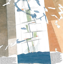
Utstillingen tar opp arkitekturens rolle i forhold til endrede forutsetninger og utfordringer som nord Jæren regionen står overfor når oljealderen går mot slutten. I de siste 40 år har oljeindustrien vært en avgjørende drivkraft i forbindelse med den omfattende utviklingen som har funnet sted. Stavanger, som Norges oljehovedstad, har gjennomgått et stort framskritt fra å være en av Norges fattigste byer til å bli en av de rikeste.
Et tilbakevendende spørsmål er hva som vil skje med videreutviklingen av byregionen når oljeressursene i Nordsjøen ikke lenger er drivkraft i den lokale økonomien.
Utstillingen er laget i samarbeid med Stavanger Arkitektforening og ARKITEKTURENS ÅR. Det er et av 3 lokale prosjekter som markerer SAF’s 75 års jubileum. AHOs master studio "Appearing and Disappearing Landscapes" (våren 2010) og Snøhettas Sandnesprosjekt presenteres i denne utstillingen. More to come.
Thursday, May 5, 2011
RECAST - scener fra Jæren

Sunday, April 3, 2011
In The Middle of The World / In The Middle of Nuuk
 We are on our way to Nuuk and Greenland.Kommuneqarfik Sermersooq, Sermersooq Municipality has in collaboration with Kalaallit Nunaanni Namminersorlutik Oqartussat, The Government of Greenland prepared a comprehensive master plan for the Tuujuk and Block, P areas. The exhibition of the Master Plan proposal for parts of the City Centre of the Capital Nuuk, titled In The Middle of The World/In The Middle of Nuuk , opens on the 5th of April. Our guests and collaborators, Minna Riska from MDH architects , Johan Berglund from 42architects + regionalasscosiates and Anders Hus Folkedal from Aspan Viak Landscape travel with us. Håkon Matre from Fantastic Norway has to stay at home, with his newly born child. In Greenland we will team up with our partners in TNT Nuuk architects and all our connections and friends. The exhibition will be open at least until the meeting of the Foreign Ministers of the Arctic Council in Nuuk from the 10th to the !6th of May. A series of discussions will follow the exhibition: To exhibit is to open up! More to come on this
 sermersooq press release: For better or worse, the Tuujuk and Block P developments stand as symbols of a time of great social and cultural challenges. But the buildings are also valued for their central location and is home to people with resources. The ties between the residents and the energy that exists, is strong. After a lifetime of 40 years, block P with its 135 apartments and 50 residential dwellings is due for demolition, and Block A - L in Tuujuk with 156 apartments will be undergoing a phased demolition over a period of years. The problem surrounding the buildings is simple - as time has passed, the housing has become outdated. In the process of rebuilding the areas, a number of important questions must be asked: What qualities exists today and what new possibilities and qualities should we aim to produce? What kind of life and environments should we strive to generate? What type of town should it be? What role could the district play in Nuuk's overall development? In short: What kind of capital city should we aim for? To answer these questions, new experiences must be acquired and new knowledge learned and understood. Our existing thought Models need to be renewed. Kommuneqarfik Sermersooq has in collaboration with The Government of Greenland prepared a comprehensive master plan for the Tuujuk and Block, P areas. The masterplan NUNARSUUP QEQQANi / / Nuup QEQQANi / In The Middle of the World / / In the Middle of NUUK has been developed after advice from Dahl & Uhre architects (Tromsø) and TNTnuuk A / S. Additionally, MDH Architects (Oslo), Fantastic Norway (Oslo), 42 architects + Regional associates (London), Asplan Viak landscape (Oslo) M: ARC and Arkitekti (Nuuk) has also contributed significantly to the project's development. The plan is developed in ongoing dialogue with residents and stakeholders and originates from a desire and willingness to provide Nuuk, the capital of Greenland, with new development opportunities for the city and its citizens. The plan seeks to ask and answer the right questions, which will be required to achieve this vision
Friday, July 23, 2010
BARCELONA BIENNALE

Five projects from our studio have been selected to be exhibited as part of AHO contribution to the 6th European Landscape Biennial in Barcelona. The INTERNATIONAL EXHIBITION OF UNIVERSITY PROJECTS IN THE SCHOOLS OF ARCHITECTURE AND LANDSCAPE will be celebrated in the Technical School Superior of Architecture of Barcelona, from the 27th of September till the 15th of October of 2010.
See the pdfs here:
> JÆREN RECONNECTED
> A NEW SEASCAPE CARTOGRAPHY / (+doc)
> SOS JÆREN / (+doc)
> AGRICULTURE LEADS THE FLOW / (+doc)
> A JOURNEY ACROSS THE PIXELATED LANDSCAPE / (+doc)
Wednesday, September 30, 2009
Scandinavian conversations on the Malmö dynamics at SLU Alnarp

Last week we were revisiting the Øresund region with our mosaïc mindset and 19 architect- and landscape architect students from Bergen School of Architecture. After studying Malmö in the virtual world for two weeks, under the headlines of New Hierarchies and Imbedded Information, it was time for us and the students to enter this field of exploration, walk the streets, meet the people and hit the dynamics and the patterns that connects.... An in depth research into the imbedded information of Malmö.
On Thursday we had conversations with prof.Carola Wingren and her students from the landscape architect department at the Swedish University of Agricultural Sciences in Alnarp.
The journalist Peter Sylwan and the head of urban straties in Malmö, Johan Emanuelson, guided us through the possible future agricultural landscape and into the growing city.
Carola Wingren's master course is dealing with how Malmö can meet future challenges from sea level rise. SLU Alnarp is set in a large, old park with thousands of species plants and trees north of Malmö. We rounded up this fine day with a walk in this beautiful park.
The Malmö findings will be posted at city as biotope under the label Elasticity.
Tuesday, September 1, 2009
master studio and blog

mosaïc::reading - the city as biotope is a master studio at Bergen School of Architecture run during the autumn term 2009 by Gisle Løkken, Magdalena Haggärde, Kjerstin Uhre and Knut Eirik Dahl. Under the themes of new hierarchies, imbedded information, elasticity, dynamic of small cultures, points of departure, vulnerability and charging the landscape with new energy different aspects, ideas and possibilities of planning will be discussed and discovered - at the school in Bergen, on study trips to Malmö and Paris and on the blog city as biotope
Thursday, July 2, 2009
Red den intakte natur før alt andet // Link // Kronik - Politiken
Rasmus Ejrnæs, seniorforsker ved Afd. for Vildtbilogi og Biodiversitet, Aarhus Universitet og Hans Henrik Bruun, docent ved Ekologiska Institutionen, Lunds Universitet har skrevet en viktig og innsiktsfull tekst om sårbarhet og naturforvaltning. Her kommer noen utdrag fra kronikken:
"....Omsat til naturforvalterens sprog lyder brandmandens lov således: Først må man redde den natur, som endnu ikke er ødelagt. Dernæst gælder det om at fjerne de negative påvirkninger fra den øvrige natur, som er under ødelæggelse. Når tilstanden i den bestående natur er gunstig, kan det give mening at etablere ny natur.Desværre har denne enkle lov aldrig vundet indpas blandt beslutningstagere højere oppe i systemet. Om det skyldes at beslutningstagerne ikke kan overskue den vilde naturs kompleksitet, eller ganske enkelt foretrækker at klippe snore ved indvielser af ny natur, kan være svært at afgøre. Men det er et spørgsmål værd, om de begrænsede midler, der afsættes til naturformål, bruges omkostningseffektivt, når brandmandens lov vendes på hovedet....
....Næringsstofferne forvilder sig ud i naturen fra landbrug og afbrænding af fossile brændstoffer. Kvælstof kommer via luften, og kvælstof og fosfor transporteres også ud i naturen med drænvandet fra de dyrkede marker. Det er velkendt, at næringsstofferne slukker lyset og skaber iltsvind i søer, fjorde og lavvandede havområder, men næringsstofferne ødelægger også levestederne på land.
Effekten kan synes knap så dramatisk på land. Her ligger fuglene ikke med bugen i vejret og gisper efter luft, men tabet af nøjsomhedsplanter, sommerfugle, vilde bier, rensdyrlaver og svampe er ikke desto mindre voldsomt. De vilde dyr, planter og svampe har aldrig tidligere i evolutionens lange historie været udsat for et lignende tæppebombardement med næringsstoffer....
....Vi vil vove den påstand, at det frem for at etablere ny natur på dyrkede marker og gødskede enge vil være langt mere omkostningseffektivt at:
• Udvide arealet med urørt skov i Danmark ved at standse den forstlige drift i eksisterende skove.
• Sikre græsning af eksisterende naturområder i Danmark, som i dag henligger uden græsning, både skove og lysåbne naturtyper.
• Beskytte eksisterende naturområder mod næringsforurening ved at udlægge dyrknings- og gødningsfrie bufferzoner i kanten af marker, hvorfra der i dag foregår udvaskning til overdrev, heder, moser, skove og enge. Ikke bare helt nede ved selve vandløbet, men oppe i kanten af marken, hvor ådalen, kystskrænten eller strandengen begynder.
• Genskabe det naturlige vandkredsløb i eksisterende naturområder ved at sløjfe dræn og grøfter og beskytte eksisterende natur mod vandindvinding...."
Knut Eirik kommenterte teksten slik: Interessant tekst! Kjenner dere kunstneren Christos prosjekt der han la rød duk rundt hver av øyene i et arkippelago utenfor Florida: Kan jeg oppfatte deres strategi dithen at dere lanserer en beskyttelsesone rundt den eksiserende natur dere vil forsterke? Nærmest som et naturarkipelago i et jordbrukshav, og at dette er en slags hovedstrategi?
Les hele kronikken her: Politiken.dk!
Friday, June 26, 2009
The aftermath of COP 15 // Nordhavnen // The Map Collection

This Map (and text) is from the 1st price project in Nordhavnen,(1st face), Copenhagen: Excentral Park - Edge Dynamics, which we did together with 70°N and a panel of experts.
Thursday, June 25, 2009
Pre COP 15 // Nordhavnen // The Map Collection

This Map (and text) is from the 1st price project in Nordhavnen, (1st face), Copenhagen: Excentral Park - Edge Dynamics, which we did together with 70°N and a panel of experts.
Monday, June 22, 2009
Bridging and Branding // Nordhavnen // The Map Collection

The competition of Ørestaden in 1994 can be seen as Copenhagen’s urban answer to the Öresund Bridge project. The program for Ørestaden was as ambitious as for Nordhavnen, but in a different time. Here the ambitions of Copenhagen as an important city in a European economic picture were dominant (new Docklands etc.) The ideal world of Ørestaden, as a line of growth out towards Amager’s periphery, have not however been sustained in dialogue with the larger image of the city. More interesting urban developments have taken place in other parts of Copenhagen, and ideas and ambitions have disintegrated in Ørestaden’s era.
Nordhavnen has now been designated as the place for seven present ambition’s criteria summed up as ‘The Sustainable City of the Future’. As in Ørestaden a linear direction of development has been chosen, but this time directly into the Øresund Strait, functioning as a game board for these ambitions. The program’s statement is that all ambitions that have not taken place other places will happen here, - not unlike the ‘best of all’-programs for Ørestaden.
This Map (and text) is from the 1st price project in Nordhavnen,(1st face), Copenhagen: Excentral Park - Edge Dynamics, which we did together with 70°N and a panel of experts.
Tuesday, June 16, 2009
Miljøstatus 2009 viser miljøutfordringene
Utslipp av klimagasser og global oppvarming er vår tids største miljøutfordring. Situasjonen er alvorlig for naturmangfoldet, på grunn av klimaendringer og andre trusler. Det viser den nye publikasjonen Miljøstatus 2009, som gir en tematisk og helhetlig oversikt over miljøutfordringene i Norge. (kilde:dirnat)
Last ned miljøstatus 2009 her
Monday, June 15, 2009
Why Here? // The Map Collection

This map was our starting point for an investigation on a city development in Stavanger in 2000. It led, together with Paolo Viganos lecture in Cordoba (Europan, 2003) to the text ”Topografiske attraksjoner” (topographical attractions), published in Arkitektnytt in 2003.
In the spring 2010 we will revisit the study field of Jæren through the course, Appearing and Disappearing Landscapes, which is part 2 of AHO's "Research on the Norwegian Landscape". The course is an inter-Nordic cooperation between the AHO and Forests and Landscape at Copenhagen University. Jæren is a region that today has the largest urban growth in Norway after Oslo. The region, which is the centre of oil development in Norway, is now entering into a new phase, causing both landscape and urbanity to be in need of reinterpretation. The course will establish recognition on the larger scale that will affect knowledge built up during the course work. The UN climate conference, COP 15, in December 2009 will send out signals concerning this larger scale.
The Course is planned as a discourse between landscapes and urban conditions that range from the smallest biotope to the larger future image. Students will throughout the semester work on individual projects as experiments in the relationship between different territorial contexts and urban strategies; this will entail both a smart and innovative cartography and conceptual design projects.
Friday, June 12, 2009
Resistance // The Map Collection

Each element, every trace describing the appearing manufactured and spiritual landscape is to be considered as resisting change, interposing processes which resists and reformulate actual interventions in space.
A canal or a lake can thus fashion a word of ideas for what is to follow. A planted forest will after 20 years demand respect and care. An area in which all of nature is subject to change during 30 years will by virtue of that change draw attention to itself and become an alternative to all development strategies. Our concept entails exploring how such an incipient landscape shapes its capacity for resistance, in other words how it is shaped in time.
We made this map over Ørestaden in 1994 as a part of The Magic Carpet.
Tuesday, May 26, 2009
D&U ONLINE PAPERS // Appearing and disappearing Landscapes

D&U ONLINE PAPERS // Appearing and disappearing Landscapes
Monday, May 25, 2009
NATURBASE // link // The Map Collection


Områder som er vernet, eller foreslått vernet, etter naturvernloven, Svalbardloven, Svalbardmiljøloven og viltloven // Naturtyper og arter som er viktige for å opprettholde mangfoldet i naturen. // Arter som har spesiell betydning for jakt og annen høsting. // Kulturlandskap med viktige biologiske og/eller kulturhistoriske verdier. // Friluftslivsområder som er sikret for allmenn bruk ved at staten har kjøpt dem eller skaffet seg spesielle rettigheter i dem. // Motorferdselsreguleringer, reinsjaktområder, ilandstigningsplasser m.m. på Svalbard.
I Sverige finnes en naturkartbase organisert av lansstyrelsene, for Skåne heter den Naturguiden med viewer.
Den tilsvarende naturkartbasen for Danmark er: Miljøportalen med arealinfo.
Sunday, May 24, 2009
Turliv på yttersia // The Map Collection
 På Bent Svinnung's interaktive kart som finner du lenker til noen av hans favorittplasser, fra Helgelandskysten til yttersia av Troms, samt en del informasjon om beliggenhet, tilgjengelighet, praktiske tips, historikk. Jeg har stor glede av å klikke på de hvite punktene på dette kartet og studere turbeskrivelser og se fantastiske bilder. Yttersida av Troms er et eldorado for dem som bedriver turliv, uansett om framdriften skjer med åre, seil, motor eller beina. Masse rullesteinsfjærer, sandstrender, holmer og skjær, egger og vegger. Nok til å ta pusten fra de aller mest blaserte.
Turliv på Yttersia,
Thursday, May 21, 2009
D&U ONLINE PAPERS // The Magic Carpet

"The urban ideals loom larger than the understanding of landscape, shining far more brightly as it were. The borders of urban space constitute an intellectual hinterland. The relation between what is built and the continued life of the landscape is destined to remain the major theme in the civic space of the future...."
D&U ONLINE PAPERS // The Magic Carpet, 1994
In 1994 we participated in the international competition for the expansion of Copenhagen, called Ørestaden. The project received the second prize in the competition. The idea universe of the project is duly published in the periodical "byplan" No. 5, 95. Through the presentation of the project's own text and a comprehensive critical review of the competition by Professor Jens Kvorning (jury member). The concept launched "The Game of Ørestaden" by setting up the structure plans as a set of playing pieces, in which different forces of change led to entirely different interpretations of this future urban landscape. The current development in Copenhagen, where other areas have come into the searchlight and are taking power from the "ideal" Ørestaden, confirms one of our statements in the competition - "The spirit of the place is bound to be found elsewhere".
Wednesday, May 20, 2009
WORLD IN DENMARK Change
Conference May 29th 2009 at Danish Architecture Center DAC
Change has become mantra: climate change, environmental, financial and political change. Change in nature and society has before resulted in change in the aesthetic language; as a sign of something upcoming or as a mirroring of something that has arrived. Is this the case in today’s urban space? Do we see and do we need new definition, new significance new use of the urban landscape and consequently a new aesthetic language in the urban space?
Though the significance belongs to the large scale the signs often start in the small – in garden art and landscape architecture.
The World in Denmark conference asks this question to landscape architects and their answers will take form as reflections and projects. The conference is arranged by Danish Centre for Forest, Landscape and Planning, University of Copenhagen in co-operation with The Association of Danish Landscape Architects.
Professor, Ph.D. Ellen Braae, University of Copenhagen // Director Kent Martinussen, Danish Architecture Centre DAC // Professor, Dr. Agro. Malene Hauxner, University of Copenhagen // Landscape architect Catherine Mosbach // Professor of urbanism Knut Eirik Dahl, Dahl & Uhre arkitekter and senior design architect Gisle Løkken, 70° N arkitektur // Artist, landscape architect and founder of Atelier Dreiseitl, Herbert Dreiseitl // Landscape architect, Ph.D. Kristine Jensen
World in Denmark, programme
Thursday, May 14, 2009
On Site
 Knut Eirik and Kjerstin writes on Appearing and Disappearing landscapes in On Site.
The first book published in 2006, Fieldwork, explored the tendency in Europe for new urban forms built on former agricultural land to use the patterns and land forms of the former agricultural use. The title, On Site, refers to attitudes to place or locus.
Aurora Carapinha (P), Lisa Diedrich (D), Ana Kučan (SLO), Lynn Kinnear (GB), Yttje Feddes (NL), Knut Eirik Dahl and Kjerstin Uhre (N), Maria Goula (E), Dirk Sijmons (NL), Jørgen Primdahl (DK), Måns Holst-Ekström (S), Giacomo Delbene (I)
Lisa Diedrich (editor-in-chief), Munich (D); Hubertus Adam, Zurich (CH); Mark Hendriks, Utrecht (NL); Ana Kučan, Ljubljana (SLO)
 On Site
Birkhauser
Thursday, December 18, 2008
Vinner for andre gang i Øresundsmetropolen


Vi, Dahl & Uhre + 70°N, med ekspertgjester, Markus Holding (Atkins Global, Malmö) og Thomas Barfoed Brandrup (Skov og Land, København), har vunnet 1. pris i den internasjonale idekonkurransen om Københavns nye byutviklingsprosjekt - Nordhavnen.
Prisen ble overrakt av Ritt Bjerregaard og Klaus Bondam i Pakhus 53 i Nordhavnen i dag.
fra dommerkomiteen:
"Det er dommerkomiteens vurdering, at prosjektet gennem sine strategier fremkommer med et egentlig nyt billede på en strukturplan og deraf følgende ny horisont for byudvikling".
Excentral Park - Edge Dynamics
Wednesday, May 21, 2008
Mosaïc::www
 A web-site for Mosaïc::Region is now up and running!
At http://www.mosaic-region.com/ you can click your way through the mosaïc; poster by poster and text by text, and you'll find our complete prize-winning proposition for the competition Øresundsvisioner 2040.
The site is under construction and will soon develop further with new material, guest comments, news etc.
Welcome into the mosaïc!